Geographical Hazards: Earthquakes & Climate
SEISMIC ACTIVITY: THE BATTLE OF FAULT LINES
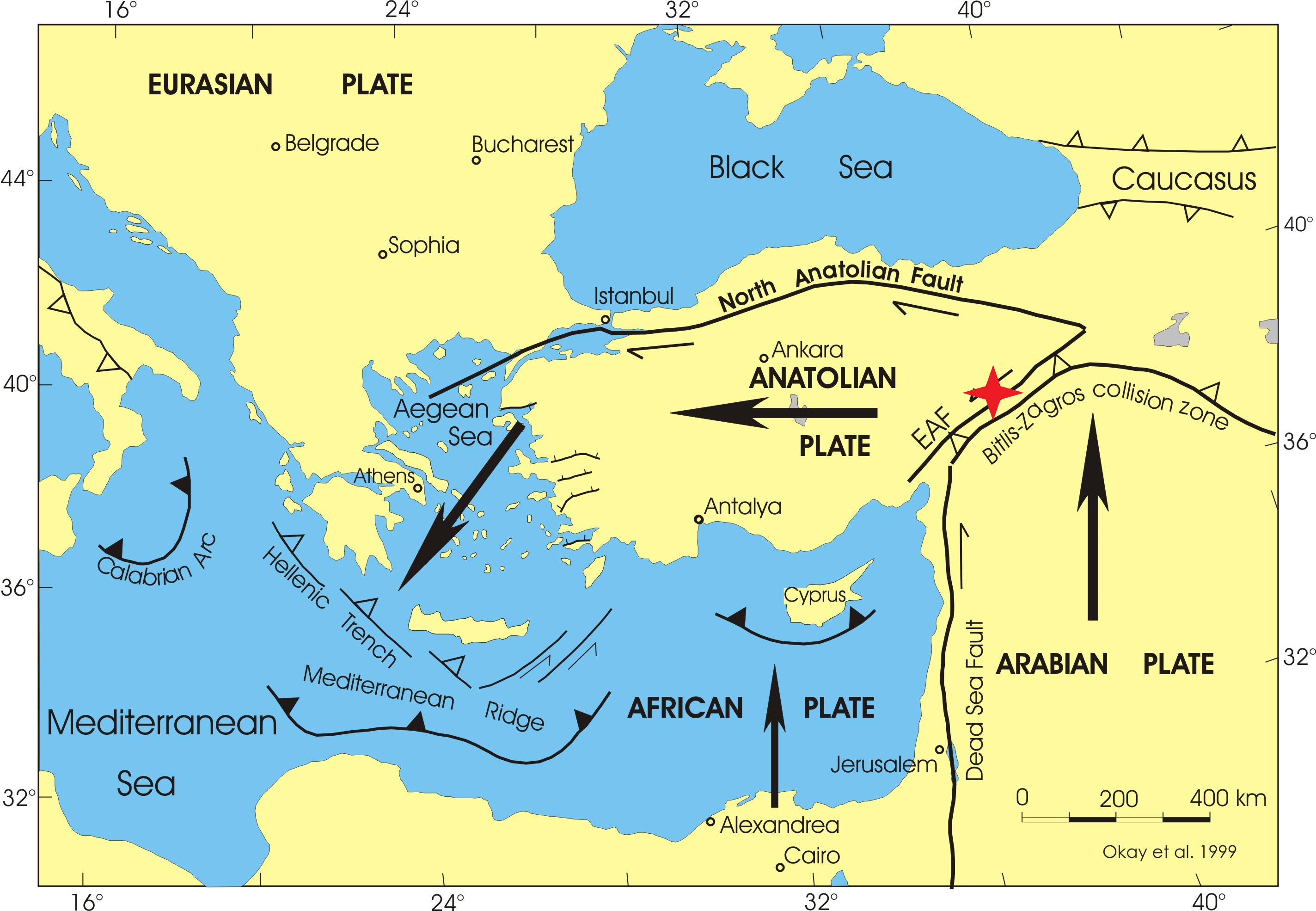
The Anatolian Microplate and Tectonics
Turkey sits on the Anatolian Microplate, which is squeezed between the Eurasian Plate and the African/Arabian Plates. The Arabian Plate continuously pushes the Anatolian Plate westward, creating immense stress along the boundaries of two main fault systems. This makes the region one of the most seismically active in the world.
North Anatolian Fault (NAF)
The NAF is an active, approximately 1500 km long strike-slip fault running along the Black Sea coast. It poses the primary threat to Istanbul, as the fault runs through the Sea of Marmara. The NAF was associated with the catastrophic 1999 İzmit earthquake.
East Anatolian Fault (EAF)
The EAF is the second major fault in Eastern Turkey, bordering the Arabian Plate. The devastating earthquakes in February 2023 (M 7.8 and M 7.5) occurred precisely on this fault. Additional Info: The meeting point of these two major faults is known as the Karlıova Triple Junction, an extremely unstable region.
CLIMATE ZONES AND GEOGRAPHICAL VARIATIONS
Mediterranean Climate (Southern and Western Coast)
Characterized by hot and dry summers and mild and rainy winters (e.g., Antalya, Izmir). This is the main tourism region. Precipitation is predominantly seasonal (winter).
Black Sea Climate (Northern Coast)
This region has a warm and humid climate year-round. It is the wettest region of Turkey (e.g., Rize), creating ideal conditions for tea cultivation.
Continental Inland Climate (Central Anatolia)
Large temperature fluctuations: scorching summers and very cold, snowy winters (e.g., Ankara, Kayseri). This region is susceptible to drought during the summer months and heavy snow in winter.
HAZARDS CAUSED BY CLIMATE CHANGE
Drought and Water Scarcity
Drought is a growing threat, particularly impacting agriculture in Central and Eastern Anatolia. Climate change leads to irregular precipitation and significantly threatens the water supply for major cities, including Istanbul and Ankara. Water conservation is a national priority.
Forest Fires and Flooding
On the Mediterranean coast (Antalya, Muğla), extremely hot summers have significantly increased the risk of widespread forest fires. Meanwhile, the Black Sea coast frequently suffers from sudden floods and landslides caused by intense rainfall.
REAL-TIME EARTHQUAKES: USGS DATA
Earthquake Measurement: Richter and Mercalli Scales
1. Richter Scale (Magnitude)
The Richter scale (more accurately: the abbreviated Moment Magnitude Scale Mw) measures the energy released at the earthquake's source. It is a logarithmic scale where each whole number step represents roughly a 32-fold increase in energy. Magnitude provides information about the size of the event, not its impact on a populated area.
- M 1.0 – M 2.9: Minor, often unnoticed or recorded only by sensitive seismographs.
- M 3.0 – M 3.9: Noticeable but rarely damaging.
- M 5.0 – M 5.9: Moderate. Can cause significant damage to poorly constructed buildings.
- M 7.0 and higher: Major, capable of causing widespread and devastating damage.
2. Mercalli Scale (Intensity)
The Mercalli Intensity Scale (EMS-98, formerly MCS) measures the earthquake's effect at a specific location. It is based on human observations, damage to buildings, and changes in the natural environment. The scale is presented with Roman numerals (I to XII).
- I – III (Weak): Felt only by a few people, often on upper floors.
- V – VII (Strong): Felt by nearly everyone; lighter objects fall; moderate damage to poor buildings.
- IX – XII (Very Strong / Catastrophic): Significant and widespread destruction. Total devastation.
Last 24 Hours Earthquakes (List)
- Loading data... Please wait.